


Seillans - Viaduc du Rayol

soca
User
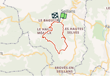

Length
11.4 km

Max alt
498 m

Uphill gradient
362 m
Km-Effort
16.3 km

Min alt
272 m

Downhill gradient
364 m
Boucle
Yes
Creation date :
2020-03-01 18:00:09.422
Updated on :
2020-03-01 18:02:48.237
3h25
Difficulty : Medium

FREE GPS app for hiking
 SityTrail
IGN / Geographical institutes
SityTrail Plus
The world is yours!
About
Trail Walking of 11.4 km to be discovered at Provence-Alpes-Côte d'Azur, Var, Seillans. This trail is proposed by soca.
Positioning
Country:
France
Region :
Provence-Alpes-Côte d'Azur
Department/Province :
Var
Municipality :
Seillans
Location:
Unknown
Start:(Dec)
Start:(UTM)
309154 ; 4833155 (32T) N.
Comments