


boncelles rosiere

lerson
User
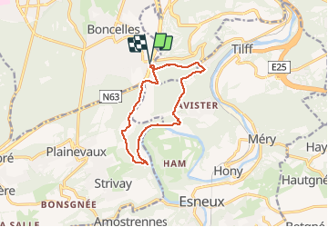

Length
10.3 km

Max alt
278 m

Uphill gradient
341 m
Km-Effort
14.8 km

Min alt
83 m

Downhill gradient
342 m
Boucle
Yes
Creation date :
2020-03-01 12:33:07.19
Updated on :
2020-03-02 08:50:48.381
3h38
Difficulty : Very easy

FREE GPS app for hiking
 SityTrail
IGN / Geographical institutes
SityTrail Plus
The world is yours!
About
Trail Walking of 10.3 km to be discovered at Wallonia, Liège, Seraing. This trail is proposed by lerson.
Positioning
Country:
Belgium
Region :
Wallonia
Department/Province :
Liège
Municipality :
Seraing
Location:
Boncelles
Start:(Dec)
Start:(UTM)
680588 ; 5604688 (31U) N.
Comments