Tourtour - Les Moulières

Sugg
User
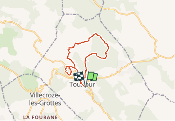

Length
13.1 km

Max alt
734 m

Uphill gradient
187 m
Km-Effort
15.6 km

Min alt
631 m

Downhill gradient
187 m
Boucle
Yes
Creation date :
2020-03-02 14:35:38.324
Updated on :
2020-03-02 14:38:02.498
5h00
Difficulty : Medium

FREE GPS app for hiking
 SityTrail
IGN / Geographical institutes
SityTrail Plus
The world is yours!
About
Trail Walking of 13.1 km to be discovered at Provence-Alpes-Côte d'Azur, Var, Tourtour. This trail is proposed by Sugg.
Description
Rando RF du 4 mars 2020.
Positioning
Country:
France
Region :
Provence-Alpes-Côte d'Azur
Department/Province :
Var
Municipality :
Tourtour
Location:
Unknown
Start:(Dec)
Start:(UTM)
282412 ; 4829633 (32T) N.
Comments