


Vergetot

DDLEDANDY
User
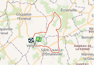

Length
11.8 km

Max alt
142 m

Uphill gradient
131 m
Km-Effort
13.5 km

Min alt
87 m

Downhill gradient
133 m
Boucle
Yes
Creation date :
2020-03-03 08:07:24.92
Updated on :
2020-03-03 10:43:31.12
2h34
Difficulty : Very easy

FREE GPS app for hiking
 SityTrail
IGN / Geographical institutes
SityTrail Plus
The world is yours!
About
Trail Walking of 11.8 km to be discovered at Normandy, Seine-Maritime, Vergetot. This trail is proposed by DDLEDANDY.
Description
Circuit principalement sur route.
facile
Positioning
Country:
France
Region :
Normandy
Department/Province :
Seine-Maritime
Municipality :
Vergetot
Location:
Unknown
Start:(Dec)
Start:(UTM)
303612 ; 5499962 (31U) N.
Comments