Trail Walking Montredon-Labessonnié - Arifat à Lagrifoul (Montredon Labessonie)  - Photo

Arifat à Lagrifoul (Montredon Labessonie)

© OpenStreetMap contributors
Length
Length
20 km
Max alt
Max alt
598 m
Uphill gradient
Uphill gradient
725 m
Km-Effort
Km-Effort  
30 km
Min alt
Min alt
276 m
Downhill gradient
Downhill gradient
725 m
Boucle
Boucle
Yes
Creation date :
2020-03-01 08:18:54.115
Updated on :
2020-03-03 14:11:55.323

(0 Reviews)

Walking
Walking
6h04
Difficulty : Medium

Scan this QR Code to open this trail in the SityTrail application

FREE GPS app for hiking

Logo SityTrail SityTrail

IGN / Geographical institutes

Download SityTrail from the App Store Download SityTrail from Google Play

Logo SityTrail SityTrail World

The world is yours!

Download SityTrail from the App Store Download SityTrail from Google Play Download SityTrail on Huawei AppGallery

About

Trail Walking of 20 km to be discovered at Occitania, Tarn, Montredon-Labessonnié. This trail is proposed by Frayssinet.

Description

En partant de lagrifoul, direction Salclas, vous êtes à mi parcours à Arifat et retour sur un chemin parfois non balisé qui évite la route. Savoir s'orienter est indispensable.

Elevation profile

Positioning

Country:
France
Region :
Occitania
Department/Province :
Tarn
Municipality :
Montredon-Labessonnié
Location:
Unknown
Start:(UTM)
446445 ; 4842933 (31T) N.

Trails nearby

Trail On foot Montredon-Labessonnié - Sentier de la Quille du Roy - Photo
On foot
PRO

On foot

Easy
Montredon-Labessonnié, Occitania, Tarn, France
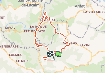
8.3 km | 11.1 km-effort
2h 31min
No
Trail Walking Montredon-Labessonnié - Sentier des agates revisité  - Photo
Walking
Isabelle Debrus

Walking

Easy
Montredon-Labessonnié, Occitania, Tarn, France
14.4 km | 20 km-effort
3h 44min
Yes
Trail Walking Montredon-Labessonnié - Sur les pas de nos ancêtres  - Photo
Walking
Manon Debrus

Walking

Easy
Montredon-Labessonnié, Occitania, Tarn, France
8.5 km | 12.5 km-effort
2h 6min
Yes
Trail Walking Arifat - cascades d'Arifat - Photo
Walking
jpipacific

Walking

Difficult
Arifat, Occitania, Tarn, France
6 km | 9.1 km-effort
1h 58min
Yes
Trail Walking Montredon-Labessonnié - Sentier de la Baronnie - Photo
Walking
tercla

Walking

Very easy
Montredon-Labessonnié, Occitania, Tarn, France
19.7 km | 27 km-effort
6h 29min
Yes
Trail Mountain bike Montredon-Labessonnié - Montredon-Labessonnié - Photo
Mountain bike
tracegps

Mountain bike

Difficult
Montredon-Labessonnié, Occitania, Tarn, France
29 km | 41 km-effort
2h 0min
No
Trail Walking Montredon-Labessonnié - 81-Montredon Labessonnie-sentier de Houlette - Photo
Walking
Jovila

Walking

Medium
Montredon-Labessonnié, Occitania, Tarn, France
20 km | 27 km-effort
4h 21min
Yes
Trail Electric bike Terre-de-Bancalié - Boucle de Roque à Roque - Photo
Electric bike
ktmetarn

Electric bike

Difficult
(1)
Terre-de-Bancalié, Occitania, Tarn, France
29 km | 41 km-effort
Unknown
Yes
Trail Walking Arifat - 81_Arifat_longue_projet - Photo
Walking
jab31

Walking

Medium
Arifat, Occitania, Tarn, France
16.1 km | 24 km-effort
4h 20min
Yes


Close
My subscriptions