


Mignavillers

danif
User
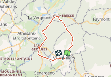

Length
11.9 km

Max alt
376 m

Uphill gradient
218 m
Km-Effort
14.8 km

Min alt
274 m

Downhill gradient
217 m
Boucle
Yes
Creation date :
2020-03-03 13:06:54.713
Updated on :
2020-03-03 17:16:11.499
3h31
Difficulty : Very easy

FREE GPS app for hiking
 SityTrail
IGN / Geographical institutes
SityTrail Plus
The world is yours!
About
Trail Walking of 11.9 km to be discovered at Bourgogne-Franche-Comté, Haute-Saône, Mignavillers. This trail is proposed by danif.
Positioning
Country:
France
Region :
Bourgogne-Franche-Comté
Department/Province :
Haute-Saône
Municipality :
Mignavillers
Location:
Unknown
Start:(Dec)
Start:(UTM)
315676 ; 5272309 (32T) N.
Comments