


luc

bouscaillou
User
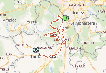

Length
16.4 km

Max alt
684 m

Uphill gradient
311 m
Km-Effort
20 km

Min alt
535 m

Downhill gradient
241 m
Boucle
No
Creation date :
2020-03-03 13:04:37.093
Updated on :
2020-03-03 20:33:26.216
7h22
Difficulty : Very easy

FREE GPS app for hiking
 SityTrail
IGN / Geographical institutes
SityTrail Plus
The world is yours!
About
Trail Nordic walking of 16.4 km to be discovered at Occitania, Aveyron, Olemps. This trail is proposed by bouscaillou.
Positioning
Country:
France
Region :
Occitania
Department/Province :
Aveyron
Municipality :
Olemps
Location:
Unknown
Start:(Dec)
Start:(UTM)
464446 ; 4909848 (31T) N.
Comments