


st jean chapelle

vincente204
User
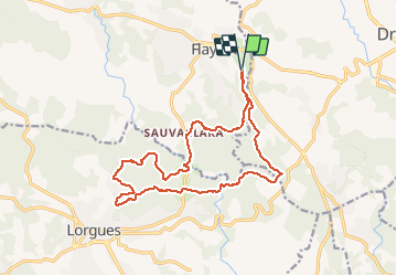

Length
17.9 km

Max alt
318 m

Uphill gradient
470 m
Km-Effort
24 km

Min alt
149 m

Downhill gradient
468 m
Boucle
Yes
Creation date :
2020-03-03 07:47:10.031
Updated on :
2020-03-03 21:48:01.731
3h08
Difficulty : Very easy

FREE GPS app for hiking
 SityTrail
IGN / Geographical institutes
SityTrail Plus
The world is yours!
About
Trail Walking of 17.9 km to be discovered at Provence-Alpes-Côte d'Azur, Var, Flayosc. This trail is proposed by vincente204.
Description
facile
Positioning
Country:
France
Region :
Provence-Alpes-Côte d'Azur
Department/Province :
Var
Municipality :
Flayosc
Location:
Unknown
Start:(Dec)
Start:(UTM)
290426 ; 4822835 (32T) N.
Comments