


Sources de l'Huveaune rando 4 mars 2020

rlebasque
User
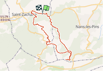

Length
22 km

Max alt
599 m

Uphill gradient
647 m
Km-Effort
30 km

Min alt
272 m

Downhill gradient
642 m
Boucle
Yes
Creation date :
2020-03-05 06:56:01.249
Updated on :
2020-03-05 16:13:48.237
6h52
Difficulty : Very easy

FREE GPS app for hiking
 SityTrail
IGN / Geographical institutes
SityTrail Plus
The world is yours!
About
Trail Walking of 22 km to be discovered at Provence-Alpes-Côte d'Azur, Var, Saint-Zacharie. This trail is proposed by rlebasque.
Positioning
Country:
France
Region :
Provence-Alpes-Côte d'Azur
Department/Province :
Var
Municipality :
Saint-Zacharie
Location:
Unknown
Start:(Dec)
Start:(UTM)
721119 ; 4807083 (31T) N.
Comments