


Ravin de Clastre - Col de Grimone

Mariolebeno
User
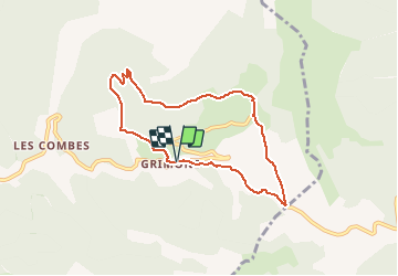

Length
7.3 km

Max alt
1453 m

Uphill gradient
377 m
Km-Effort
12.3 km

Min alt
1119 m

Downhill gradient
381 m
Boucle
Yes
Creation date :
2020-03-06 10:25:46.82
Updated on :
2020-03-06 10:45:02.806
2h00
Difficulty : Very easy

FREE GPS app for hiking
 SityTrail
IGN / Geographical institutes
SityTrail Plus
The world is yours!
About
Trail On foot of 7.3 km to be discovered at Auvergne-Rhône-Alpes, Drôme, Glandage. This trail is proposed by Mariolebeno.
Positioning
Country:
France
Region :
Auvergne-Rhône-Alpes
Department/Province :
Drôme
Municipality :
Glandage
Location:
Unknown
Start:(Dec)
Start:(UTM)
708931 ; 4952600 (31T) N.
Comments