


Creisset_gpx

RobinMicheline
User GUIDE
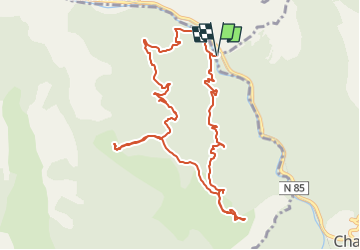

Length
11.9 km

Max alt
1154 m

Uphill gradient
617 m
Km-Effort
20 km

Min alt
636 m

Downhill gradient
618 m
Boucle
Yes
Creation date :
2020-03-06 10:31:10.803
Updated on :
2022-10-22 14:12:51.578
5m
Difficulty : Medium

FREE GPS app for hiking
 SityTrail
IGN / Geographical institutes
SityTrail Plus
The world is yours!
About
Trail On foot of 11.9 km to be discovered at Provence-Alpes-Côte d'Azur, Alpes-de-Haute-Provence, Chaudon-Norante. This trail is proposed by RobinMicheline.
Positioning
Country:
France
Region :
Provence-Alpes-Côte d'Azur
Department/Province :
Alpes-de-Haute-Provence
Municipality :
Chaudon-Norante
Location:
Unknown
Start:(Dec)
Start:(UTM)
282388 ; 4875745 (32T) N.
Comments