


24-FEV-19

TOULAUDIN
User

Length
15.5 km

Max alt
1002 m

Uphill gradient
958 m
Km-Effort
28 km

Min alt
198 m

Downhill gradient
964 m
Boucle
Yes
Creation date :
2020-03-07 09:03:12.791
Updated on :
2020-03-07 09:26:11.597
--
Difficulty : Medium

FREE GPS app for hiking
 SityTrail
IGN / Geographical institutes
SityTrail Plus
The world is yours!
About
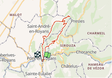
Trail On foot of 15.5 km to be discovered at Auvergne-Rhône-Alpes, Isère, Pont-en-Royans. This trail is proposed by TOULAUDIN.
Description
rando faite le 24/2/19 avec les Eisclops St Perollais au départ de Pont en Royans pas de difficultés mais assez long et partie route
Photos


Positioning
Country:
France
Region :
Auvergne-Rhône-Alpes
Department/Province :
Isère
Municipality :
Pont-en-Royans
Location:
Unknown
Start:(Dec)
Start:(UTM)
684556 ; 4992213 (31T) N.
Comments