


dentelles le truc

Joel26400
User
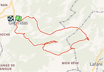

Length
12.7 km

Max alt
584 m

Uphill gradient
592 m
Km-Effort
21 km

Min alt
239 m

Downhill gradient
592 m
Boucle
Yes
Creation date :
2020-03-07 07:51:57.292
Updated on :
2020-03-07 14:57:28.4
5h01
Difficulty : Medium

FREE GPS app for hiking
 SityTrail
IGN / Geographical institutes
SityTrail Plus
The world is yours!
About
Trail Walking of 12.7 km to be discovered at Provence-Alpes-Côte d'Azur, Vaucluse, Gigondas. This trail is proposed by Joel26400.
Description
belle rendo
Positioning
Country:
France
Region :
Provence-Alpes-Côte d'Azur
Department/Province :
Vaucluse
Municipality :
Gigondas
Location:
Unknown
Start:(Dec)
Start:(UTM)
660159 ; 4891940 (31T) N.
Comments