


Les 3 Doms

jpblimond
User

Length
21 km

Max alt
117 m

Uphill gradient
187 m
Km-Effort
23 km

Min alt
63 m

Downhill gradient
187 m
Boucle
Yes
Creation date :
2020-03-07 11:48:03.594
Updated on :
2020-03-09 07:26:38.364
5h04
Difficulty : Medium

FREE GPS app for hiking
 SityTrail
IGN / Geographical institutes
SityTrail Plus
The world is yours!
About
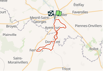
Trail Walking of 21 km to be discovered at Hauts-de-France, Somme, Montdidier. This trail is proposed by jpblimond.
Description
Chemin difficilement praticable entre "La Cressonière" et la "Vallée Coulevin". Des arbres ont été abattus. La circulation des Bulldozers a fortement endommagé le chemin.
Positioning
Country:
France
Region :
Hauts-de-France
Department/Province :
Somme
Municipality :
Montdidier
Location:
Unknown
Start:(Dec)
Start:(UTM)
468312 ; 5498436 (31U) N.
Comments