


CHARTREUSE - Rocher de l'église depuis Rigaudière

JMHRX2
User
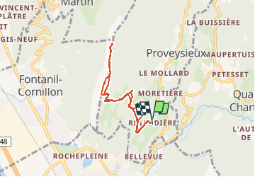

Length
6.9 km

Max alt
1218 m

Uphill gradient
747 m
Km-Effort
16.9 km

Min alt
448 m

Downhill gradient
749 m
Boucle
Yes
Creation date :
2020-03-07 08:46:02.877
Updated on :
2020-03-08 13:06:27.586
2h35
Difficulty : Very easy

FREE GPS app for hiking
 SityTrail
IGN / Geographical institutes
SityTrail Plus
The world is yours!
About
Trail Walking of 6.9 km to be discovered at Auvergne-Rhône-Alpes, Isère, Proveysieux. This trail is proposed by JMHRX2.
Positioning
Country:
France
Region :
Auvergne-Rhône-Alpes
Department/Province :
Isère
Municipality :
Proveysieux
Location:
Unknown
Start:(Dec)
Start:(UTM)
711310 ; 5014155 (31T) N.
Comments