


Rando vtt avec Jérôme

PascalBanide
User
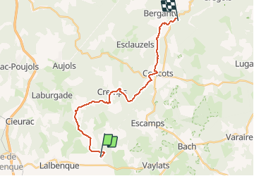

Length
21 km

Max alt
364 m

Uphill gradient
392 m
Km-Effort
26 km

Min alt
215 m

Downhill gradient
343 m
Boucle
No
Creation date :
2020-02-23 10:59:12.0
Updated on :
2020-03-08 14:32:07.273
2h27
Difficulty : Unknown

FREE GPS app for hiking
 SityTrail
IGN / Geographical institutes
SityTrail Plus
The world is yours!
About
Trail Mountain bike of 21 km to be discovered at Occitania, Lot, Lalbenque. This trail is proposed by PascalBanide.
Positioning
Country:
France
Region :
Occitania
Department/Province :
Lot
Municipality :
Lalbenque
Location:
Unknown
Start:(Dec)
Start:(UTM)
387445 ; 4911015 (31T) N.
Comments