


SAINT JEAN EN ROYANS

nordan
User
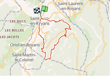

Length
17.7 km

Max alt
984 m

Uphill gradient
825 m
Km-Effort
29 km

Min alt
243 m

Downhill gradient
814 m
Boucle
Yes
Creation date :
2020-03-08 08:32:36.438
Updated on :
2020-03-08 15:12:10.545
6h23
Difficulty : Very easy

FREE GPS app for hiking
 SityTrail
IGN / Geographical institutes
SityTrail Plus
The world is yours!
About
Trail Walking of 17.7 km to be discovered at Auvergne-Rhône-Alpes, Drôme, Saint-Jean-en-Royans. This trail is proposed by nordan.
Positioning
Country:
France
Region :
Auvergne-Rhône-Alpes
Department/Province :
Drôme
Municipality :
Saint-Jean-en-Royans
Location:
Unknown
Start:(Dec)
Start:(UTM)
680550 ; 4987746 (31T) N.
Comments