


Lac des Tavernes- G3

lmc
User
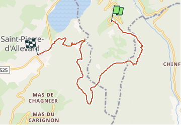

Length
8.2 km

Max alt
1173 m

Uphill gradient
307 m
Km-Effort
13.5 km

Min alt
526 m

Downhill gradient
655 m
Boucle
No
Creation date :
2020-03-10 09:18:09.764
Updated on :
2020-03-10 09:21:51.371
--
Difficulty : Easy

FREE GPS app for hiking
 SityTrail
IGN / Geographical institutes
SityTrail Plus
The world is yours!
About
Trail On foot of 8.2 km to be discovered at Auvergne-Rhône-Alpes, Isère, Allevard. This trail is proposed by lmc.
Positioning
Country:
France
Region :
Auvergne-Rhône-Alpes
Department/Province :
Isère
Municipality :
Allevard
Location:
Unknown
Start:(Dec)
Start:(UTM)
271041 ; 5029254 (32T) N.
Comments