


Gerland 7.1 10 03 2020

jtraverse
User
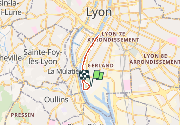

Length
7.1 km

Max alt
171 m

Uphill gradient
29 m
Km-Effort
7.5 km

Min alt
160 m

Downhill gradient
27 m
Boucle
Yes
Creation date :
2020-03-10 13:03:11.535
Updated on :
2020-03-10 15:30:08.604
2h26
Difficulty : Easy

FREE GPS app for hiking
 SityTrail
IGN / Geographical institutes
SityTrail Plus
The world is yours!
About
Trail Walking of 7.1 km to be discovered at Auvergne-Rhône-Alpes, Métropole de Lyon, Lyon. This trail is proposed by jtraverse.
Positioning
Country:
France
Region :
Auvergne-Rhône-Alpes
Department/Province :
Métropole de Lyon
Municipality :
Lyon
Location:
Lyon 7e Arrondissement
Start:(Dec)
Start:(UTM)
642141 ; 5064777 (31T) N.
Comments