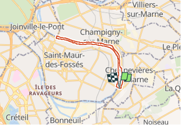
J 18 12 km Pont de Chennevières

Les 1000 pattes
Club randonnées SERVON

Length
11 km

Max alt
54 m

Uphill gradient
75 m
Km-Effort
12 km

Min alt
31 m

Downhill gradient
71 m
Boucle
Yes
Creation date :
2020-03-10 12:31:21.447
Updated on :
2025-01-24 09:57:36.741
2h42
Difficulty : Medium

FREE GPS app for hiking
 SityTrail
IGN / Geographical institutes
SityTrail Plus
The world is yours!
About
Trail Walking of 11 km to be discovered at Ile-de-France, Val-de-Marne, Chennevières-sur-Marne. This trail is proposed by Les 1000 pattes.
Description
Parking rue de l'Etape Chennevières
bord de marne St Maur Champigny
Photos


Positioning
Country:
France
Region :
Ile-de-France
Department/Province :
Val-de-Marne
Municipality :
Chennevières-sur-Marne
Location:
Unknown
Start:(Dec)
Start:(UTM)
464968 ; 5404254 (31U) N.
Comments