


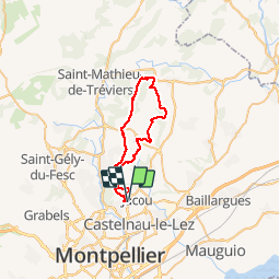
clapiers ste croix de quintaillargues

ARVIEU
User

Length
39 km

Max alt
265 m

Uphill gradient
677 m
Km-Effort
48 km

Min alt
60 m

Downhill gradient
675 m
Boucle
Yes
Creation date :
2014-12-10 00:00:00.0
Updated on :
2014-12-10 00:00:00.0
3h06
Difficulty : Medium

FREE GPS app for hiking
 SityTrail
IGN / Geographical institutes
SityTrail Plus
The world is yours!
About
Trail Mountain bike of 39 km to be discovered at Occitania, Hérault, Clapiers. This trail is proposed by ARVIEU.
Description
clapiers à Ste croix de Quintillargues par le mont Negre et le Bois de Mouniè
Positioning
Country:
France
Region :
Occitania
Department/Province :
Hérault
Municipality :
Clapiers
Location:
Unknown
Start:(Dec)
Start:(UTM)
572670 ; 4834469 (31T) N.
Comments