


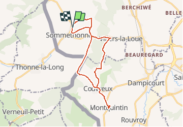
de Sommethonne à Montquintin

dragonchef
User


--
Difficulty : Very difficult

FREE GPS app for hiking
 SityTrail
IGN / Geographical institutes
SityTrail Plus
The world is yours!
About
Trail On foot of 13.8 km to be discovered at Wallonia, Luxembourg, Meix-devant-Virton. This trail is proposed by dragonchef.
Description
Au départ de Sommethonne, une fois arrivé sur les hauteurs, observez cette vue imprenable, vous apercevrez la Basilique d'Avioth avant de vous rendre au chateau de Montquintin où vous aurez une vue imprenable sur le paysage gaumais( table d'orientation, musée, ..)
Cette marche de 14kms est très très sportive
Positioning
Comments