


la gk

tosan
User

Length
28 km

Max alt
429 m

Uphill gradient
1098 m
Km-Effort
43 km

Min alt
4 m

Downhill gradient
1068 m
Boucle
No
Creation date :
2020-03-11 07:53:36.628
Updated on :
2020-03-12 00:43:17.893
8h25
Difficulty : Very easy

FREE GPS app for hiking
 SityTrail
IGN / Geographical institutes
SityTrail Plus
The world is yours!
About
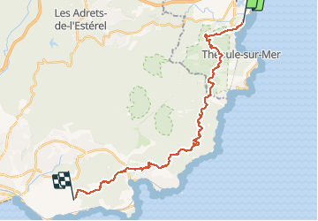
Trail Walking of 28 km to be discovered at Provence-Alpes-Côte d'Azur, Maritime Alps, Mandelieu-la-Napoule. This trail is proposed by tosan.
Positioning
Country:
France
Region :
Provence-Alpes-Côte d'Azur
Department/Province :
Maritime Alps
Municipality :
Mandelieu-la-Napoule
Location:
Unknown
Start:(Dec)
Start:(UTM)
333628 ; 4821076 (32T) N.
Comments