


Saubens petir tour fait

pidjam
User
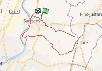

Length
8.3 km

Max alt
195 m

Uphill gradient
68 m
Km-Effort
9.2 km

Min alt
159 m

Downhill gradient
67 m
Boucle
Yes
Creation date :
2020-03-12 12:43:30.305
Updated on :
2020-03-12 14:49:16.306
2h05
Difficulty : Very easy

FREE GPS app for hiking
 SityTrail
IGN / Geographical institutes
SityTrail Plus
The world is yours!
About
Trail Walking of 8.3 km to be discovered at Occitania, Haute-Garonne, Saubens. This trail is proposed by pidjam.
Positioning
Country:
France
Region :
Occitania
Department/Province :
Haute-Garonne
Municipality :
Saubens
Location:
Unknown
Start:(Dec)
Start:(UTM)
366899 ; 4815450 (31T) N.
Comments