


Rians mont Vautubière

bernir
User
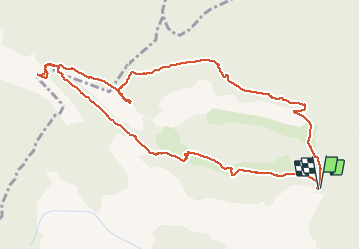

Length
12.3 km

Max alt
656 m

Uphill gradient
366 m
Km-Effort
17.2 km

Min alt
370 m

Downhill gradient
366 m
Boucle
Yes
Creation date :
2020-03-12 08:54:48.366
Updated on :
2020-03-12 18:40:18.037
6h24
Difficulty : Easy

FREE GPS app for hiking
 SityTrail
IGN / Geographical institutes
SityTrail Plus
The world is yours!
About
Trail Walking of 12.3 km to be discovered at Provence-Alpes-Côte d'Azur, Var, Rians. This trail is proposed by bernir.
Positioning
Country:
France
Region :
Provence-Alpes-Côte d'Azur
Department/Province :
Var
Municipality :
Rians
Location:
Unknown
Start:(Dec)
Start:(UTM)
721521 ; 4834309 (31T) N.
Comments