


Anse Michel

ericlaurenty
User
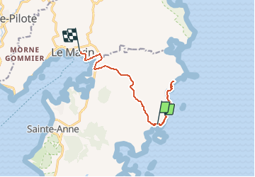

Length
14.8 km

Max alt
79 m

Uphill gradient
213 m
Km-Effort
17.6 km

Min alt
0 m

Downhill gradient
210 m
Boucle
No
Creation date :
2020-03-12 15:32:16.0
Updated on :
2020-03-12 19:19:22.809
3h45
Difficulty : Unknown

FREE GPS app for hiking
 SityTrail
IGN / Geographical institutes
SityTrail Plus
The world is yours!
About
Trail Walking of 14.8 km to be discovered at Martinique, Unknown, Sainte-Anne. This trail is proposed by ericlaurenty.
Description
A
Positioning
Country:
France
Region :
Martinique
Department/Province :
Unknown
Municipality :
Sainte-Anne
Location:
Unknown
Start:(Dec)
Start:(UTM)
734059 ; 1597176 (20P) N.
Comments