


13.03.2020 - PLOUER À TADEN

babeth35
User
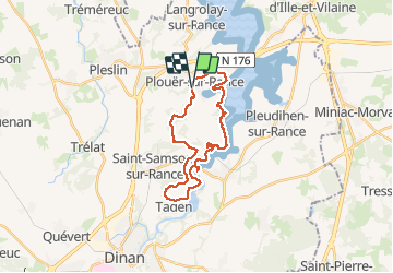

Length
24 km

Max alt
82 m

Uphill gradient
366 m
Km-Effort
28 km

Min alt
3 m

Downhill gradient
360 m
Boucle
Yes
Creation date :
2020-03-13 07:40:48.0
Updated on :
2020-03-13 16:34:00.125
6h32
Difficulty : Difficult

FREE GPS app for hiking
 SityTrail
IGN / Geographical institutes
SityTrail Plus
The world is yours!
About
Trail Walking of 24 km to be discovered at Brittany, Côtes-d'Armor, Plouër-sur-Rance. This trail is proposed by babeth35.
Positioning
Country:
France
Region :
Brittany
Department/Province :
Côtes-d'Armor
Municipality :
Plouër-sur-Rance
Location:
Unknown
Start:(Dec)
Start:(UTM)
573519 ; 5375095 (30U) N.
Comments