


Le Béout en boucle Rando 65

mitch1952
User
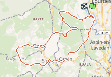

Length
13.7 km

Max alt
782 m

Uphill gradient
648 m
Km-Effort
22 km

Min alt
376 m

Downhill gradient
648 m
Boucle
Yes
Creation date :
2020-03-14 18:49:39.816
Updated on :
2022-06-07 09:45:03.313
4h35
Difficulty : Very difficult

FREE GPS app for hiking
 SityTrail
IGN / Geographical institutes
SityTrail Plus
The world is yours!
About
Trail Walking of 13.7 km to be discovered at Occitania, Hautespyrenees, Lourdes. This trail is proposed by mitch1952.
Positioning
Country:
France
Region :
Occitania
Department/Province :
Hautespyrenees
Municipality :
Lourdes
Location:
Unknown
Start:(Dec)
Start:(UTM)
739790 ; 4774937 (30T) N.
Comments