


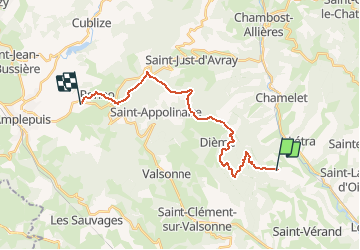
J3 - Monts du lyonnais - Ternand > Ronno

aeldin
User

Length
19.8 km

Max alt
880 m

Uphill gradient
877 m
Km-Effort
31 km

Min alt
437 m

Downhill gradient
772 m
Boucle
No
Creation date :
2020-03-09 10:00:45.191
Updated on :
2020-06-15 17:23:49.333
--
Difficulty : Very easy
--
Difficulty : Very easy

FREE GPS app for hiking
 SityTrail
IGN / Geographical institutes
SityTrail Plus
The world is yours!
About
Trail Fishing of 19.8 km to be discovered at Auvergne-Rhône-Alpes, Rhône, Ternand. This trail is proposed by aeldin.

Positioning
Country:
France
Region :
Auvergne-Rhône-Alpes
Department/Province :
Rhône
Municipality :
Ternand
Location:
Unknown
Start:(Dec)
Start:(UTM)
616787 ; 5089369 (31T) N.
Comments