


Croix de chamrousse par lac Robert ski de rando

psesjs
User
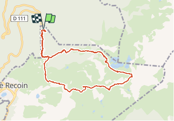

Length
11.2 km

Max alt
2250 m

Uphill gradient
913 m
Km-Effort
23 km

Min alt
1399 m

Downhill gradient
913 m
Boucle
Yes
Creation date :
2014-12-10 00:00:00.0
Updated on :
2014-12-10 00:00:00.0
4h35
Difficulty : Unknown

FREE GPS app for hiking
 SityTrail
IGN / Geographical institutes
SityTrail Plus
The world is yours!
About
Trail Other activity of 11.2 km to be discovered at Auvergne-Rhône-Alpes, Isère, Chamrousse. This trail is proposed by psesjs.
Positioning
Country:
France
Region :
Auvergne-Rhône-Alpes
Department/Province :
Isère
Municipality :
Chamrousse
Location:
Unknown
Start:(Dec)
Start:(UTM)
727098 ; 5002599 (31T) N.
Comments