


Monnière - Sampans - Mont Joly

cmike39
User
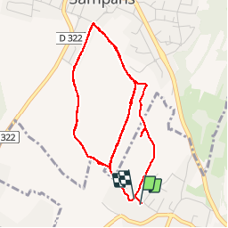

Length
7.2 km

Max alt
291 m

Uphill gradient
130 m
Km-Effort
8.9 km

Min alt
225 m

Downhill gradient
125 m
Boucle
Yes
Creation date :
2014-12-10 00:00:00.0
Updated on :
2014-12-10 00:00:00.0
1h45
Difficulty : Medium

FREE GPS app for hiking
 SityTrail
IGN / Geographical institutes
SityTrail Plus
The world is yours!
About
Trail Nordic walking of 7.2 km to be discovered at Bourgogne-Franche-Comté, Jura, Monnières. This trail is proposed by cmike39.
Positioning
Country:
France
Region :
Bourgogne-Franche-Comté
Department/Province :
Jura
Municipality :
Monnières
Location:
Unknown
Start:(Dec)
Start:(UTM)
686423 ; 5220671 (31T) N.
Comments