


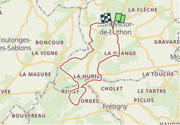
St Victor de Buthon 14.5

togolo28
User

Length
14.5 km

Max alt
257 m

Uphill gradient
302 m
Km-Effort
18.5 km

Min alt
155 m

Downhill gradient
305 m
Boucle
Yes
Creation date :
2014-12-10 00:00:00.0
Updated on :
2014-12-10 00:00:00.0
3h58
Difficulty : Medium

FREE GPS app for hiking
 SityTrail
IGN / Geographical institutes
SityTrail Plus
The world is yours!
About
Trail Walking of 14.5 km to be discovered at Centre-Loire Valley, Eure-et-Loir, Saint-Victor-de-Buthon. This trail is proposed by togolo28.
Positioning
Country:
France
Region :
Centre-Loire Valley
Department/Province :
Eure-et-Loir
Municipality :
Saint-Victor-de-Buthon
Location:
Unknown
Start:(Dec)
Start:(UTM)
349602 ; 5363702 (31U) N.
Comments