


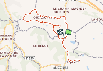
succieu nivolas fichaillon

m261212
User

Length
11 km

Max alt
461 m

Uphill gradient
229 m
Km-Effort
14.1 km

Min alt
384 m

Downhill gradient
230 m
Boucle
Yes
Creation date :
2020-03-16 15:12:27.024
Updated on :
2020-03-16 16:10:09.385
4h00
Difficulty : Very easy

FREE GPS app for hiking
 SityTrail
IGN / Geographical institutes
SityTrail Plus
The world is yours!
About
Trail On foot of 11 km to be discovered at Auvergne-Rhône-Alpes, Isère, Succieu. This trail is proposed by m261212.
Positioning
Country:
France
Region :
Auvergne-Rhône-Alpes
Department/Province :
Isère
Municipality :
Succieu
Location:
Unknown
Start:(Dec)
Start:(UTM)
682807 ; 5045586 (31T) N.
Comments