


mafliers

bendoush
User

Length
9.6 km

Max alt
201 m

Uphill gradient
203 m
Km-Effort
12.3 km

Min alt
92 m

Downhill gradient
207 m
Boucle
Yes
Creation date :
2020-03-17 13:28:20.427
Updated on :
2020-03-17 15:40:18.306
2h11
Difficulty : Very easy

FREE GPS app for hiking
 SityTrail
IGN / Geographical institutes
SityTrail Plus
The world is yours!
About
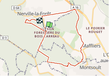
Trail Walking of 9.6 km to be discovered at Ile-de-France, Val-d'Oise, Nerville-la-Forêt. This trail is proposed by bendoush.
Positioning
Country:
France
Region :
Ile-de-France
Department/Province :
Val-d'Oise
Municipality :
Nerville-la-Forêt
Location:
Unknown
Start:(Dec)
Start:(UTM)
447890 ; 5437014 (31U) N.
Comments