


Abbaye, fontaine en forêt

bianchireg
User
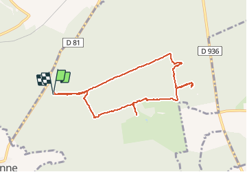

Length
7.7 km

Max alt
168 m

Uphill gradient
85 m
Km-Effort
8.8 km

Min alt
134 m

Downhill gradient
83 m
Boucle
Yes
Creation date :
2020-03-18 13:17:56.24
Updated on :
2020-03-18 15:57:19.844
2h06
Difficulty : Very easy

FREE GPS app for hiking
 SityTrail
IGN / Geographical institutes
SityTrail Plus
The world is yours!
About
Trail Walking of 7.7 km to be discovered at Hauts-de-France, Aisne, Villers-Cotterêts. This trail is proposed by bianchireg.
Photos


Positioning
Country:
France
Region :
Hauts-de-France
Department/Province :
Aisne
Municipality :
Villers-Cotterêts
Location:
Unknown
Start:(Dec)
Start:(UTM)
504584 ; 5451335 (31U) N.
Comments