


Lockdown day 2 😊

seghth
User
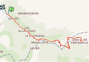

Length
13.6 km

Max alt
1575 m

Uphill gradient
518 m
Km-Effort
21 km

Min alt
1064 m

Downhill gradient
530 m
Boucle
Yes
Creation date :
2020-03-18 10:26:41.95
Updated on :
2020-03-18 22:32:18.914
4h21
Difficulty : Very easy

FREE GPS app for hiking
 SityTrail
IGN / Geographical institutes
SityTrail Plus
The world is yours!
About
Trail Walking of 13.6 km to be discovered at Auvergne-Rhône-Alpes, Upper Savoy, Morzine. This trail is proposed by seghth.
Description
Morzine - Croix de Fecherolle, via lac des mines d'or
Positioning
Country:
France
Region :
Auvergne-Rhône-Alpes
Department/Province :
Upper Savoy
Municipality :
Morzine
Location:
Unknown
Start:(Dec)
Start:(UTM)
324279 ; 5114534 (32T) N.
Comments