Trail Mountain bike Béduer - Beduer - Lalbenque - Photo

Beduer - Lalbenque

 Gpoujade
Gpoujade

User

© OpenStreetMap contributors
Length
Length
67 km
Max alt
Max alt
400 m
Uphill gradient
Uphill gradient
1234 m
Km-Effort
Km-Effort  
83 km
Min alt
Min alt
142 m
Downhill gradient
Downhill gradient
1233 m
Boucle
Boucle
No
Creation date :
2020-03-20 16:06:19.184
Updated on :
2020-03-23 15:50:03.676

(0 Reviews)

Mountain bike
Mountain bike
5h29
Difficulty : Very difficult

Scan this QR Code to open this trail in the SityTrail application

FREE GPS app for hiking

Logo SityTrail SityTrail

IGN / Geographical institutes

Download SityTrail from the App Store Download SityTrail from Google Play

Logo SityTrail SityTrail World

The world is yours!

Download SityTrail from the App Store Download SityTrail from Google Play Download SityTrail on Huawei AppGallery

About

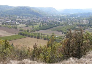
Trail Mountain bike of 67 km to be discovered at Occitania, Lot, Béduer. This trail is proposed by Gpoujade.

Description

En suivant le plus possible, le tracé du Tour Du lot qui passe par Cajarc, Limogne En Quercy, Varaire

Elevation profile

Positioning

Country:
France
Region :
Occitania
Department/Province :
Lot
Municipality :
Béduer
Location:
Unknown
Start:(UTM)
416631 ; 4936898 (31T) N.

Trails nearby

Trail Walking Corn - Corn source bleue  - Photo
Walking
houbart

Walking

Difficult
(1)
Corn, Occitania, Lot, France
11.7 km | 16.3 km-effort
3h 42min
Yes
Trail Walking Corn - Le causse par lacoste - Photo
Walking
sebcar

Walking

Very easy
(1)
Corn, Occitania, Lot, France
8.4 km | 11.7 km-effort
2h 38min
Yes
Trail Walking Corn - Sainte Eulalie Crayssac - Photo
Walking
sebcar

Walking

Very easy
Corn, Occitania, Lot, France
11.7 km | 16.6 km-effort
3h 31min
Yes
Trail Walking Corn - Corn Mas de  Léret - Photo
Walking
sebcar

Walking

Very easy
Corn, Occitania, Lot, France
4.1 km | 5.8 km-effort
1h 43min
Yes
Trail Walking Faycelles - Mon Compostelle sixième étape - Photo
Walking
Ardeiserois

Walking

Difficult
Faycelles, Occitania, Lot, France
43 km | 55 km-effort
9h 40min
No
Trail Equestrian Lissac-et-Mouret - La Cazelle-Camburat-Mouret-La Cazelle - Photo
Equestrian
dcarreau

Equestrian

Easy
(1)
Lissac-et-Mouret, Occitania, Lot, France
13.9 km | 17.5 km-effort
2h 43min
Yes
Trail Walking Gréalou - Gréalou à Larnagol - Photo
Walking
dominiq

Walking

Very difficult
Gréalou, Occitania, Lot, France
19.5 km | 24 km-effort
6h 51min
No
Trail Mountain bike Corn - beduer crayssac - Photo
Mountain bike
sebcar

Mountain bike

Easy
Corn, Occitania, Lot, France
15.7 km | 21 km-effort
1h 54min
Yes
Trail Mountain bike Faycelles - figeac cassagnole  st cirq la popie - Photo
Mountain bike
lablaquiere

Mountain bike

Medium
Faycelles, Occitania, Lot, France
68 km | 89 km-effort
9h 21min
No


Close
My subscriptions