


FIGEAC Ste EULALIE

gallo
User
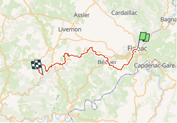

Length
41 km

Max alt
351 m

Uphill gradient
1200 m
Km-Effort
57 km

Min alt
164 m

Downhill gradient
1233 m
Boucle
No
Creation date :
2020-03-20 17:27:06.808
Updated on :
2020-03-20 17:55:41.118
7h12
Difficulty : Very difficult

FREE GPS app for hiking
 SityTrail
IGN / Geographical institutes
SityTrail Plus
The world is yours!
About
Trail Walking of 41 km to be discovered at Occitania, Lot, Figeac. This trail is proposed by gallo.
Positioning
Country:
France
Region :
Occitania
Department/Province :
Lot
Municipality :
Figeac
Location:
Unknown
Start:(Dec)
Start:(UTM)
423356 ; 4939928 (31T) N.
Comments