


22MMK 2020 B

Lamartiniere
User GUIDE
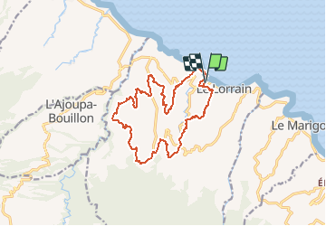

Length
22 km

Max alt
349 m

Uphill gradient
836 m
Km-Effort
34 km

Min alt
3 m

Downhill gradient
836 m
Boucle
Yes
Creation date :
2020-03-13 22:39:32.536
Updated on :
2020-03-13 22:44:01.171
--
Difficulty : Difficult

FREE GPS app for hiking
 SityTrail
IGN / Geographical institutes
SityTrail Plus
The world is yours!
About
Trail On foot of 22 km to be discovered at Martinique, Unknown, Le Lorrain. This trail is proposed by Lamartiniere.
Description
Nouvelle mouture du 22MMK 2020 avec petite déviation sur la Crabière jsuqu'au pont "Encikili".
Positioning
Country:
France
Region :
Martinique
Department/Province :
Unknown
Municipality :
Le Lorrain
Location:
Unknown
Start:(Dec)
Start:(UTM)
708512 ; 1640959 (20P) N.
Comments