


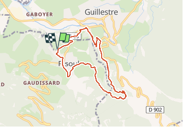
Risoul: Le Villaret Peyre Haute

Sorriaux
User

Length
8.6 km

Max alt
1187 m

Uphill gradient
316 m
Km-Effort
12.8 km

Min alt
970 m

Downhill gradient
316 m
Boucle
Yes
Creation date :
2020-03-21 11:09:23.94
Updated on :
2020-03-21 14:40:06.703
2h48
Difficulty : Easy

FREE GPS app for hiking
 SityTrail
IGN / Geographical institutes
SityTrail Plus
The world is yours!
About
Trail Walking of 8.6 km to be discovered at Provence-Alpes-Côte d'Azur, Hautes-Alpes, Guillestre. This trail is proposed by Sorriaux.
Description
Risoul le Villaret, la rua, la ferme de Chagne, peyre haute, peyre basse, Guillestre, le villaret
Photos


Positioning
Country:
France
Region :
Provence-Alpes-Côte d'Azur
Department/Province :
Hautes-Alpes
Municipality :
Guillestre
Location:
Unknown
Start:(Dec)
Start:(UTM)
312482 ; 4947094 (32T) N.
Comments