


Merksplas - Corona 2

pmps
User
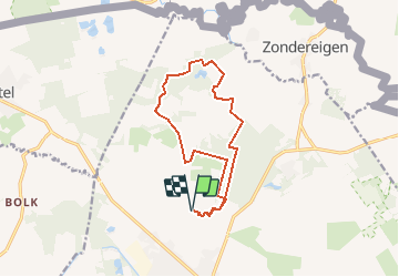

Length
11.7 km

Max alt
34 m

Uphill gradient
72 m
Km-Effort
12.6 km

Min alt
18 m

Downhill gradient
72 m
Boucle
Yes
Creation date :
2020-03-24 12:33:24.237
Updated on :
2020-03-24 12:34:10.215
--
Difficulty : Very easy

FREE GPS app for hiking
 SityTrail
IGN / Geographical institutes
SityTrail Plus
The world is yours!
About
Trail Trail of 11.7 km to be discovered at Flanders, Antwerp, Merksplas. This trail is proposed by pmps.
Positioning
Country:
Belgium
Region :
Flanders
Department/Province :
Antwerp
Municipality :
Merksplas
Location:
Merksplas
Start:(Dec)
Start:(UTM)
629289 ; 5693128 (31U) N.
Comments