Trail Walking Évisa - Evisa - Ota - Photo
© OpenStreetMap contributors
Length
Length
10.5 km
Max alt
Max alt
827 m
Uphill gradient
Uphill gradient
392 m
Km-Effort
Km-Effort  
17.4 km
Min alt
Min alt
206 m
Downhill gradient
Downhill gradient
866 m
Boucle
Boucle
No
Creation date :
2015-04-15 00:00:00.0
Updated on :
2015-04-15 00:00:00.0

(0 Reviews)

Walking
Walking
4h40
Difficulty : Medium

Scan this QR Code to open this trail in the SityTrail application

FREE GPS app for hiking

Logo SityTrail SityTrail

IGN / Geographical institutes

Download SityTrail from the App Store Download SityTrail from Google Play

Logo SityTrail SityTrail World

The world is yours!

Download SityTrail from the App Store Download SityTrail from Google Play Download SityTrail on Huawei AppGallery

About

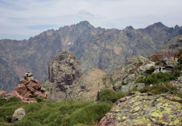
Trail Walking of 10.5 km to be discovered at Corsica, South Corsica, Évisa. This trail is proposed by CorsicaNatura.

Description

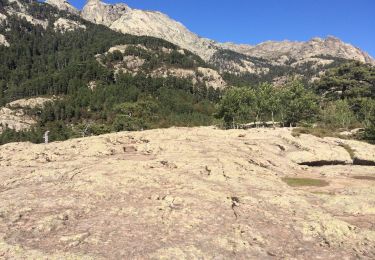
Du gite prendre la route direction plein ouest pour rejoindre la D84 et redescendre le village, après 1 Km de route (passage devant la gendarmerie et le centre de secours d’Evisa) vous arrivez devant le panneau «EVISA vous remercie de votre visite»  le sentier part à droite entre  les deux chapelles en granite (alti 804).
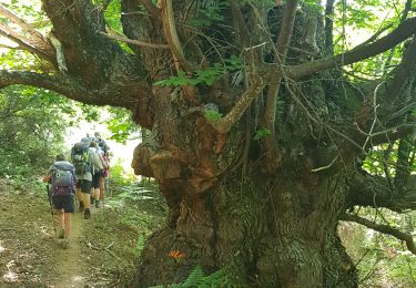
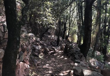
Vous empruntez le sentier de la SPELUNCA lequel est agrémenté de petits panonceaux explicatifs sur la faune et la flore insulaire.
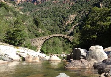
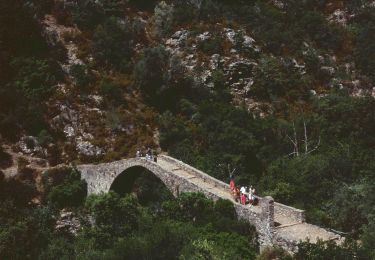
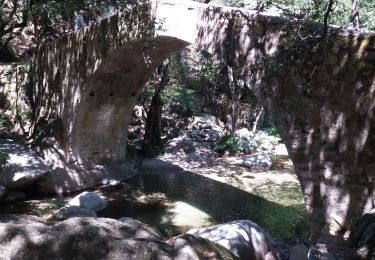
Longue descente en lacets, puis, à l’altitude 288 m, vous découvrirez sur le sentier le pont de ZAGLIA . Plus loin à environ 1/2 de marche vous coupez maintenant la D124 au pont routier d’OTA.

NB : Possibilité d’emprunter un sentier à droite, tout de suite après les deux ponts, en ALLER /RETOUR  1h environ  nouvellement ouvert pour pique niquer auprès de vasques naturelles  (itinéraire en violet sur l’extrait de carte jour)

De retour sur la route goudronnée, retraversez les deux ponts à gauche et montez 100 mètres sur la route. Pour continuer sur le MARE E MONTI balisage orange le sentier part à droite , longe le stade de football pour traverser a nouveau le fleuve par le somptueux pont génois d’Ota.
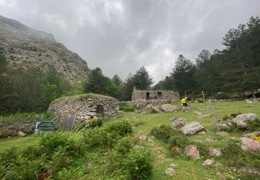
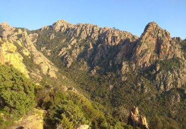
Suivre le sentier qui monte progressivement jusqu’à OTA. Au centre du village, Gîte chez FELIX , géré par Joelle Ceccaldi.

Elevation profile

Positioning

Country:
France
Region :
Corsica
Department/Province :
South Corsica
Municipality :
Évisa
Location:
Unknown
Start:(UTM)
483853 ; 4677810 (32T) N.

Trails nearby

Trail Walking Ota - gorges de la spelunca et pont, ota, corse - Photo
Walking
Bzh56

Walking

Easy
(1)
Ota, Corsica, South Corsica, France
2.9 km | 4.5 km-effort
58min
No
Trail Walking Évisa - Corse 2023: Evisa - Refuge de Puscaghia - Photo
Walking
dauzata

Walking

Difficult
Évisa, Corsica, South Corsica, France
16.6 km | 29 km-effort
6h 35min
No
Trail Walking Ota - Ota Mariniana - Photo
Walking
avdem

Walking

Medium
Ota, Corsica, South Corsica, France
473 km | 0 m-effort
11h 45min
No
Trail On foot Ota - Ota canyons - Photo
On foot
PRO

On foot

Medium
Ota, Corsica, South Corsica, France
13.5 km | 27 km-effort
6h 5min
Yes
Trail Walking Évisa - Evisa forêt d’aitone  - Photo
Walking
GUIDE
antignacs

Walking

Easy
Évisa, Corsica, South Corsica, France
13.4 km | 19.7 km-effort
4h 11min
Yes
Trail Walking Évisa - gorges spelunca - Photo
Walking
fab0202

Walking

Easy
Évisa, Corsica, South Corsica, France
4.7 km | 7.5 km-effort
1h 46min
No
Trail Walking Ota - Gorge de spelunca  - Photo
Walking
chifmichel

Walking

Ota, Corsica, South Corsica, France
10.6 km | 19 km-effort
4h 24min
Yes
Trail Walking Ota - Corse 2018 sentier des gorges - Photo
Walking
PatDev

Walking

Easy
Ota, Corsica, South Corsica, France
14.5 km | 25 km-effort
4h 27min
Yes
Trail Walking Ota - Ota  - Barghiana - Photo
Walking
tracegps

Walking

Very difficult
Ota, Corsica, South Corsica, France
49 km | 94 km-effort
30h 0min
No


Close
My subscriptions