


28/03

CatherinePerrin
User
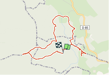

Length
5.6 km

Max alt
1138 m

Uphill gradient
140 m
Km-Effort
7.4 km

Min alt
1028 m

Downhill gradient
145 m
Boucle
Yes
Creation date :
2020-03-28 13:34:02.355
Updated on :
2020-03-28 17:14:38.119
3h39
Difficulty : Very easy

FREE GPS app for hiking
 SityTrail
IGN / Geographical institutes
SityTrail Plus
The world is yours!
About
Trail Walking of 5.6 km to be discovered at Auvergne-Rhône-Alpes, Loire, Estivareilles. This trail is proposed by CatherinePerrin.
Positioning
Country:
France
Region :
Auvergne-Rhône-Alpes
Department/Province :
Loire
Municipality :
Estivareilles
Location:
Unknown
Start:(Dec)
Start:(UTM)
575938 ; 5031660 (31T) N.
Comments