


confinement

ra2000
User
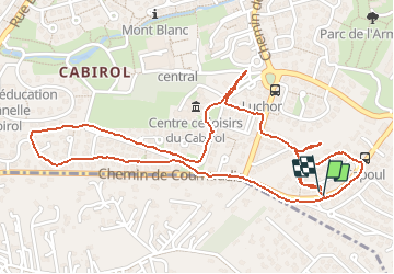

Length
3.3 km

Max alt
191 m

Uphill gradient
37 m
Km-Effort
3.8 km

Min alt
160 m

Downhill gradient
36 m
Boucle
Yes
Creation date :
2020-04-02 15:08:15.367
Updated on :
2020-04-02 16:04:10.394
55m
Difficulty : Very easy

FREE GPS app for hiking
 SityTrail
IGN / Geographical institutes
SityTrail Plus
The world is yours!
About
Trail Walking of 3.3 km to be discovered at Occitania, Haute-Garonne, Colomiers. This trail is proposed by ra2000.
Positioning
Country:
France
Region :
Occitania
Department/Province :
Haute-Garonne
Municipality :
Colomiers
Location:
Unknown
Start:(Dec)
Start:(UTM)
366160 ; 4828129 (31T) N.
Comments