Trail Walking Thueyts - Thueyts-Vernéde-Fargebelle-Bouchard - Photo

Thueyts-Vernéde-Fargebelle-Bouchard

 Lustou
Lustou

User

© OpenStreetMap contributors
Length
Length
7.8 km
Max alt
Max alt
789 m
Uphill gradient
Uphill gradient
458 m
Km-Effort
Km-Effort  
13.9 km
Min alt
Min alt
401 m
Downhill gradient
Downhill gradient
457 m
Boucle
Boucle
Yes
Creation date :
2020-04-03 08:31:04.01
Updated on :
2020-12-05 18:00:32.747

(0 Reviews)

Walking
Walking
4h00
Difficulty : Easy

Scan this QR Code to open this trail in the SityTrail application

FREE GPS app for hiking

Logo SityTrail SityTrail

IGN / Geographical institutes

Download SityTrail from the App Store Download SityTrail from Google Play

Logo SityTrail SityTrail World

The world is yours!

Download SityTrail from the App Store Download SityTrail from Google Play Download SityTrail on Huawei AppGallery

About

Trail Walking of 7.8 km to be discovered at Auvergne-Rhône-Alpes, Ardèche, Thueyts. This trail is proposed by Lustou.

Description

Thueyts vu d'avion!!!
Un peu de hors piste (50 m) entre de repère 1 et le repère 2

Elevation profile

Photos

Points of interest

Point of interest Thueyts - Repère 1 - Photo
Lustou
THUEYTS 
Point of interest Thueyts - Repère 2 - Photo
Lustou
THUEYTS 

Positioning

Country:
France
Region :
Auvergne-Rhône-Alpes
Department/Province :
Ardèche
Municipality :
Thueyts
Location:
Unknown
Start:(UTM)
596087 ; 4947257 (31T) N.

Trails nearby

Trail Walking Jaujac - Jaujac Le Ventapet 14km - Photo
Walking
GUIDE
thonyc

Walking

Very difficult
(1)
Jaujac, Auvergne-Rhône-Alpes, Ardèche, France
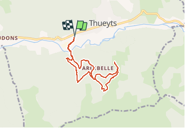
13.6 km | 23 km-effort
5h 18min
Yes
Trail Walking Saint-Pierre-de-Colombier - SityTrail - 2775482 - st-pierre-burzet - Photo
Walking
coureursdecretes

Walking

Very difficult
(1)
Saint-Pierre-de-Colombier, Auvergne-Rhône-Alpes, Ardèche, France
11.5 km | 17.1 km-effort
4h 45min
Yes
Trail Walking Meyras - neyrac les bains - Photo
Walking
raab

Walking

Easy
(1)
Meyras, Auvergne-Rhône-Alpes, Ardèche, France
4.4 km | 6.8 km-effort
1h 36min
Yes
Trail Walking Jaujac - 07_jaujac_Orgues_9km360m - Photo
Walking
SyMA

Walking

Medium
Jaujac, Auvergne-Rhône-Alpes, Ardèche, France
9.1 km | 13.8 km-effort
3h 7min
Yes
Trail Walking Barnas - 231220 Barnas  - Photo
Walking
Rudy07

Walking

Medium
Barnas, Auvergne-Rhône-Alpes, Ardèche, France
6.7 km | 9.9 km-effort
2h 15min
Yes
Trail Walking Thueyts - 231217 Thueyts-Brige - Photo
Walking
Rudy07

Walking

Easy
(1)
Thueyts, Auvergne-Rhône-Alpes, Ardèche, France
5.7 km | 9.6 km-effort
2h 11min
Yes
Trail Walking La Souche - La Souche : de Montflat au Rocher du Midi avec un retour par les Rudils - Photo
Walking
jeannine grandjean

Walking

Difficult
La Souche, Auvergne-Rhône-Alpes, Ardèche, France
6.8 km | 12.8 km-effort
2h 53min
Yes
Trail Walking Meyras - Balade Neyrac Bas - Neyrac haut - Souihol - Photo
Walking
coureursdecretes

Walking

Medium
(1)
Meyras, Auvergne-Rhône-Alpes, Ardèche, France
5.9 km | 9 km-effort
2h 2min
Yes
Trail Walking Thueyts - Thueyts-Autureyre-4 chemins-La Teyre - Photo
Walking
coureursdecretes

Walking

Medium
Thueyts, Auvergne-Rhône-Alpes, Ardèche, France
13.2 km | 20 km-effort
4h 28min
Yes


Close
My subscriptions