


TOUR DU FAING

surceneux
User
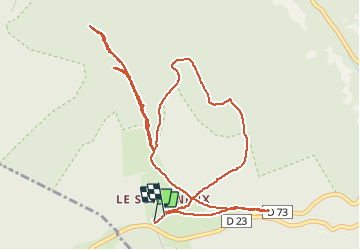

Length
6.2 km

Max alt
982 m

Uphill gradient
238 m
Km-Effort
9.3 km

Min alt
814 m

Downhill gradient
233 m
Boucle
Yes
Creation date :
2020-04-07 16:01:45.103
Updated on :
2020-04-07 17:30:50.202
1h15
Difficulty : Easy

FREE GPS app for hiking
 SityTrail
IGN / Geographical institutes
SityTrail Plus
The world is yours!
About
Trail Walking of 6.2 km to be discovered at Grand Est, Vosges, Ban-sur-Meurthe-Clefcy. This trail is proposed by surceneux.
Description
BOUCLE AU DESSUS DU SURCENEUX FAUSSES ROUTES🙂
Positioning
Country:
France
Region :
Grand Est
Department/Province :
Vosges
Municipality :
Ban-sur-Meurthe-Clefcy
Location:
Unknown
Start:(Dec)
Start:(UTM)
347782 ; 5329033 (32U) N.
Comments