ACTIVE LOG 001

philou6351
User
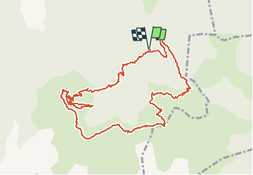

Length
13.6 km

Max alt
1605 m

Uphill gradient
755 m
Km-Effort
24 km

Min alt
1047 m

Downhill gradient
759 m
Boucle
Yes
Creation date :
2020-04-10 20:08:29.361
Updated on :
2020-04-10 20:09:02.733
4h47
Difficulty : Medium

FREE GPS app for hiking
 SityTrail
IGN / Geographical institutes
SityTrail Plus
The world is yours!
About
Trail Walking of 13.6 km to be discovered at Occitania, Ariège, Saint-Lary. This trail is proposed by philou6351.


Positioning
Country:
France
Region :
Occitania
Department/Province :
Ariège
Municipality :
Saint-Lary
Location:
Unknown
Start:(Dec)
Start:(UTM)
327467 ; 4751008 (31T) N.
Comments