Amay Villers

Steinier
User
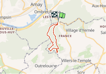

Length
8.1 km

Max alt
240 m

Uphill gradient
198 m
Km-Effort
10.7 km

Min alt
101 m

Downhill gradient
200 m
Boucle
Yes
Creation date :
2020-04-11 09:57:20.0
Updated on :
2020-04-11 11:44:08.572
1h46
Difficulty : Unknown

FREE GPS app for hiking
 SityTrail
IGN / Geographical institutes
SityTrail Plus
The world is yours!
About
Trail Walking of 8.1 km to be discovered at Wallonia, Liège, Nandrin. This trail is proposed by Steinier.
Positioning
Country:
Belgium
Region :
Wallonia
Department/Province :
Liège
Municipality :
Nandrin
Location:
Villers-le-Temple
Start:(Dec)
Start:(UTM)
666512 ; 5600932 (31U) N.
Comments