


courses_15

DomifaC
User
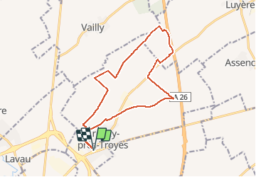

Length
15.2 km

Max alt
219 m

Uphill gradient
161 m
Km-Effort
17.4 km

Min alt
108 m

Downhill gradient
162 m
Boucle
Yes
Creation date :
2020-03-26 06:53:06.661
Updated on :
2020-04-13 10:16:24.654
1h12
Difficulty : Medium

FREE GPS app for hiking
 SityTrail
IGN / Geographical institutes
SityTrail Plus
The world is yours!
About
Trail Running of 15.2 km to be discovered at Grand Est, Aube, Creney-près-Troyes. This trail is proposed by DomifaC.
Positioning
Country:
France
Region :
Grand Est
Department/Province :
Aube
Municipality :
Creney-près-Troyes
Location:
Unknown
Start:(Dec)
Start:(UTM)
583254 ; 5353577 (31U) N.
Comments