


mareliers nord

bernir
User
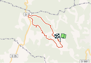

Length
7.1 km

Max alt
394 m

Uphill gradient
109 m
Km-Effort
8.6 km

Min alt
323 m

Downhill gradient
111 m
Boucle
Yes
Creation date :
2020-04-01 13:22:53.739
Updated on :
2020-04-13 10:35:35.084
5h31
Difficulty : Very easy

FREE GPS app for hiking
 SityTrail
IGN / Geographical institutes
SityTrail Plus
The world is yours!
About
Trail Walking of 7.1 km to be discovered at Provence-Alpes-Côte d'Azur, Var, Barjols. This trail is proposed by bernir.
Positioning
Country:
France
Region :
Provence-Alpes-Côte d'Azur
Department/Province :
Var
Municipality :
Barjols
Location:
Unknown
Start:(Dec)
Start:(UTM)
740614 ; 4827003 (31T) N.
Comments